Steve Rudd claims that he only seeks to determine the truth. This author knows that Steve Rudd is prepared to reject anything that puts him at odds with what his money source desires. His maligning of Ron Wyatt is no exception.
Ron Wyatt's Nuweiba Beach crossing, Egypt rejected for being impossible.
The video "Exodus Revealed" and "The Exodus Case" by Lennart Mueller are all Wyatt's work. The Gold of Exodus is worthless to truth. "Ron Wyatt is neither an archaeologist nor has he ever carried out a legally licensed excavation in Israel or Jerusalem. In order to excavate one must have at least a BA in archaeology which he does not possess despite his claims to the contrary. ... [Ron Wyatt's work] fall into the category of trash which one finds in tabloids such as the National Enquirer, Sun etc." Archaeologist Joe Zias of Israel Antiquities Authority, IAA. Bob Cornuke's The Exodus Decoded, and video, "The exodus Conspiracy" are as worthless as the work of Ron Wyatt and must be discarded. Wyatt's archeological work on Mt. Sinai is also worthless, without any factual basis and must be rejected.
Now, there are many artifacts that are hidden from the public. The main reason is that if the public knew the truth, those who seek to gain power over people would find themselves wanting. Human nature tends to be competitive and leans towards self-exaltation rather than acknowledging the truth. Professional archaeologists, such as Joe Zias, dislike being overshadowed by amateurs who uncover ancient mysteries. The fear of losing career advancement, future financial rewards, political backlash, and threats if they sanction finds that contradict the official narrative are reasons why Ron Wyatt's discoveries are dismissed.
It is often easier to attack the amateur and claim he is an imposter who has no right to discover ancient sites that trained professionals do not permit. Why? Because they are gatekeepers. Unless the gatekeeper allows someone in, there is no sanction. They attack the person with ad hominem arguments, asserting that he isn’t qualified to discover anything; they charge him with being an imposter, even though he does not claim to be a professional archaeologist or possess any academic training in the field.
Yet professional field archaeologist Jonathan Gray (deceased) validated all of Wyatt's findings at Nuweiba Beach. He is renowned for his work Dead Men's Secrets.
Part Three
 |
The Exodus Route! We propose:
|
- Rejected Red Sea Crossing points:
- REJECTED: Nuweiba Beach: The impossible crossing As proposed by Ron Wyatt: The video "Exodus Revealed" and "The Exodus Case" by Lennart Mueller are all Wyatt's work. The Gold of Exodus is worthless to truth. "Ron Wyatt is neither an archaeologist nor has he ever carried out a legally licensed excavation in Israel or Jerusalem. In order to excavate one must have at least a BA in archaeology which he does not possess despite his claims to the contrary. ... [Ron Wyatt's work] fall into the category of trash which one finds in tabloids such as the National Enquirer, Sun etc." Archaeologist Joe Zias of Israel Antiquities Authority, IAA. Bob Cornuke's The Exodus Decoded, and video, "The exodus Conspiracy" are as worthless as the work of Ron Wyatt and must be discarded. Wyatt's archeological work on Mt. Sinai is also worthless, without any factual basis and must be rejected.
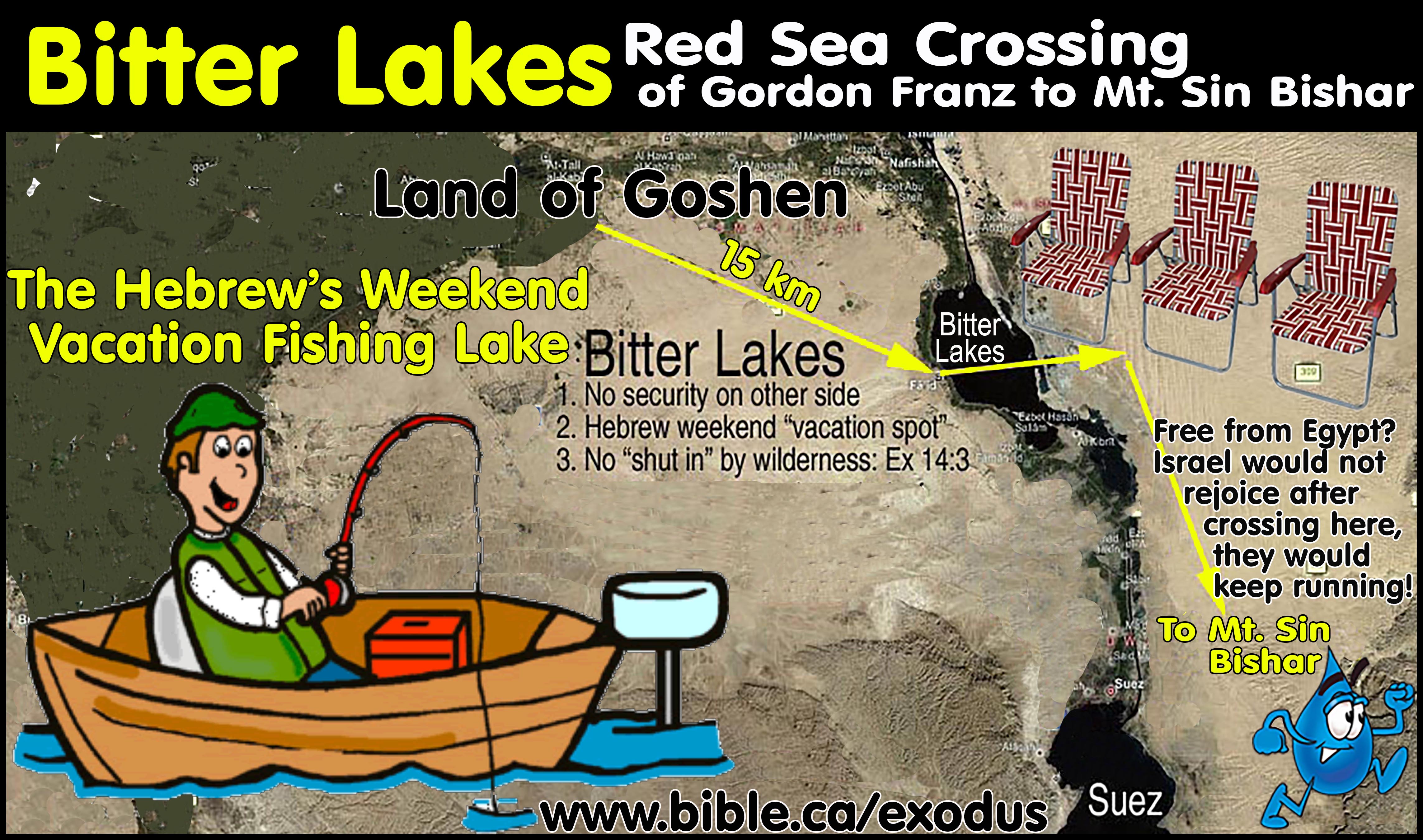
- REJECTED: Lake Sirbonis, Ballah Lake, Bitter lakes
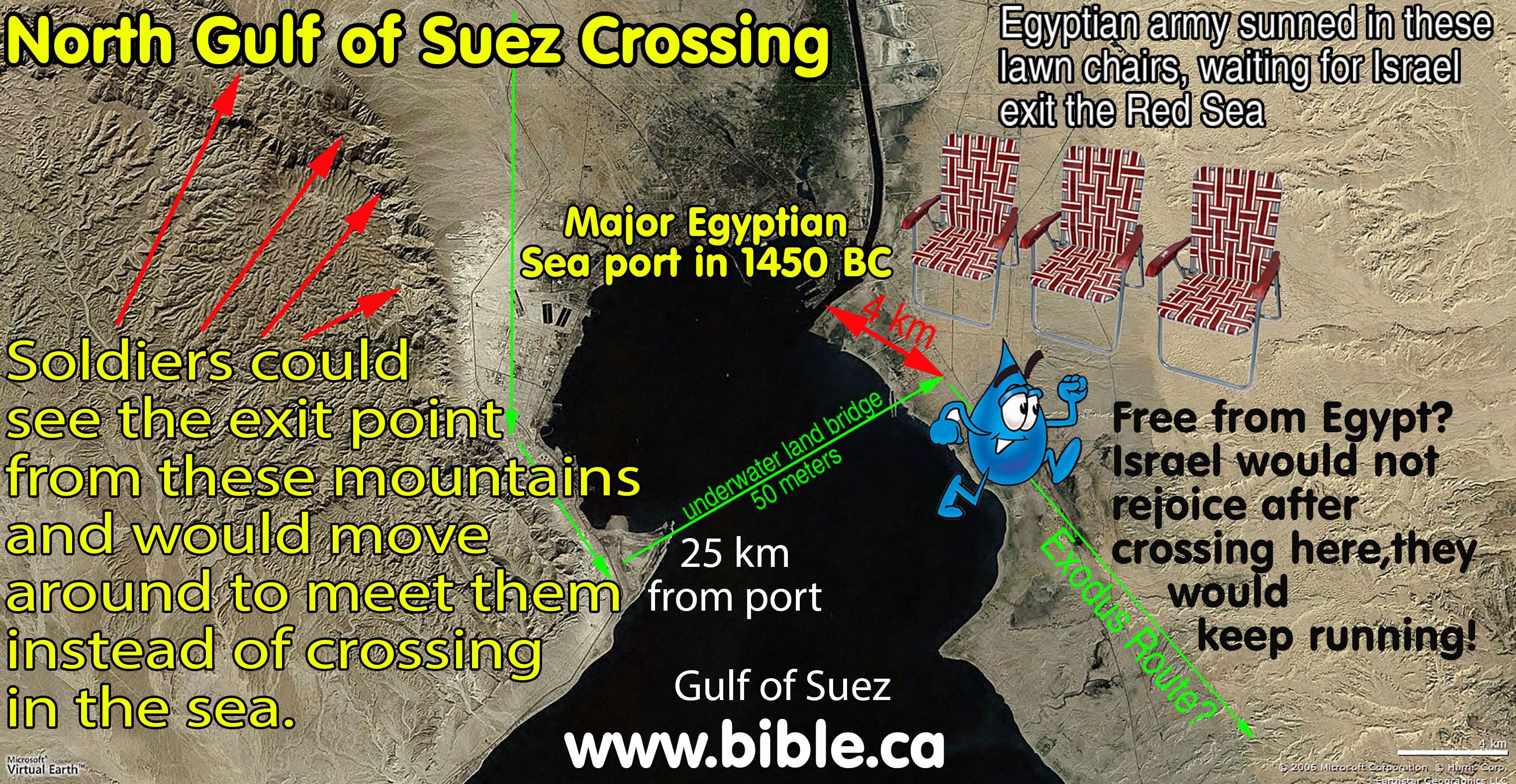
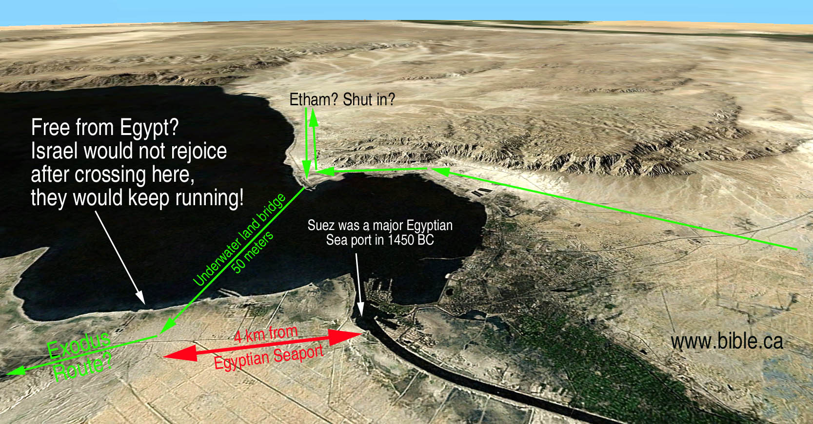
- REJECTED: Port of Suez
- Rejected Mt. Sinai candidates:
- REJECTED: Mt. Musa (at St. Catherine's monastery) Entirely Inside Egypt
- REJECTED: Mt. Karkom (Inside promised land)
- REJECTED: Mt. Khashm et-Tarif and Esh-Shairah or Shera (Inside Egypt, Midian must be located at El Bad in modern Saudi Arabia, overlooks the need to pass through Ezion Geber on route to Kadesh at Qudeirat, unless Kadesh is located at Petra)
- Rejected Kadesh Barnea candidates: Ein el-Qudeirat
 Overview map (Click on photo for high resolution) |  Satellite map(Click on photo for high resolution) |
- Many preachers realize that only 3 of the 50 locations are known for sure of the exodus route and conclude we cannot know and it doesn't matter anyway. Consequently, very little effort is put into analyzing many of the exodus routes.
- We believe it is as important to faith as it is to truth.
- We examined all the proposed exodus routes, Red Sea crossing points, choices for Mt. Sinai and Kadesh Barnea and have excluded many because they contradict the Bible or assault one's own common sense.
- There are very serious problems with the traditional exodus route which we will expose.
- These routes that travel north or east contradict the Bible. They did not take the direct eastern route called "the way of the land of the Philistines", (Ex 13:17-18) which was also known as the Way of Horus", where Egypt had a series of defensive outposts filled with garrisons of soldiers dotted along this route. This rules out any Red Sea crossing points on the Mediterranean sea like "Lake Sirbonis" or "Lake Menzaleh".
- Recently "Ballah Lake" has been proposed by James K. Hoffmeier in his book, "Ancient Israel in Sinai: The Evidence for the Authenticity of the Wilderness Tradition". This is a dried up lake that was drained when the canal was dug.
- Ex 13:17-18 also rules out any candidate locations for Mt. Sinai north of the line drawn from Goshen to Ezion Geber (Elat, north Gulf of Aqaba)
- Here are three crossing points which should be forever: Lake Sirbonis, Bitter Lakes, North Suez. We call it "red light, green light".
- Red Light (very bad choice): Lake Sirbonis "crossing" to a Mt. Sinai candidate north of the line between Goshen and modern Elat.
- Yellow light (illogical choice): Bitter Lakes crossing to Mt. Musa chosen by Queen Helena in a dream in 325 AD.
- Amber light (best of the lot, but still wrong): Port of Suez crossing to Mt. Musa chosen by Queen Helena in a dream in 325 AD.
- Green light is the actual exodus route down to the Straits of Tiran crossing over into modern Saudi Arabia where Mt. Sinai is located. (Jebel Al-Lawz)
 | |
Contradicts the Bible
|
These routes that travel north or east contradict the Bible. They did not take the direct eastern route called "the way of the land of the Philistines", (Ex 13:17-18) which was also known as the Way of Horus", where Egypt had a series of defensive outposts filled with garrisons of soldiers dotted along this route. This rules out any crossing points on the Mediterranean sea like "Lake Sirbonis" or "Lake Menzaleh".
No wall of water on either side: 1 Cor 10:1-4
No wilderness before the crossing: Ex 13:18; Judg 11:16.
Not far enough away to justify their bitter complaints about being in the wilderness: Exodus 14:11-12
|
Denies the miracle
|
Chosen because wind can create a natural land bridge, therefore requires no miracle.
|
Assaults common sense
|
Too close to Goshen.
Army would never pass through the sea, but move to the "other side of the sea" as Hebrews exit the Sea.
No security from Egypt on other side. Israel would not rejoice, they would keep running!
Pillar of fire need couldn't hold back army and is still needed after the crossing point.
Illogical route: Hebrews would have no reason to stop there, but keep running.
|
Etham doesn't fit
We propose the Red Sea crossing at Neweiba Beach
|
The Mediterranean is beside a large flat plain with no mountains. Etham: no place for wilderness to "shut them in", doesn't pass the crossing point to Etham then return again and camp at the crossing point. (Click on photos for high resolution)
 |
 | |
Contradicts the Bible
|
No wall of water on either side.
No wilderness before the crossing: Ex 13:18; Judg 11:16.
|
Denies the miracle
|
Chosen because wind can create a natural land bridge, therefore requires no miracle.
|
Assaults common sense
|
Too close to Goshen: 30 km: "Hebrew weekend fishing hole"
It is not deep enough to drown the Pharaoh's army: Pharaoh's army sank to the bottom like a stone in deep, mighty, raging waters! Exodus 15:5, 10
Army would never pass through the sea, but move to the "other side of the sea" as Hebrews exit the Sea.
No security from Egypt on other side. Israel would not rejoice, they would keep running!
No wall of water on either side: 1 Cor 10:1-4
Pillar of fire need couldn't hold back army and is still needed after the crossing point.
Illogical route: Hebrews would never stop there, but go around the lake and keep running.
Not far enough away to justify their bitter complaints about being in the wilderness: Exodus 14:11-12
Being a freshwater body of water, would provide drinkable water and food.
|
Etham doesn't fit
|
Ballah Lake and the Bitter lakes are in the middle of a large flat plain with no mountains. Etham: no place for wilderness to "shut them in", doesn't pass the crossing point to Etham then return again and camp at the crossing point. (Click on photos for high resolution)
|
Doesn't fit the context
|
Etham: no place for wilderness to "shut them in", doesn't pass the crossing point to Etham then return again and camp at the crossing point.
We propose the Red Sea crossing at the Straits of Tiran.
|
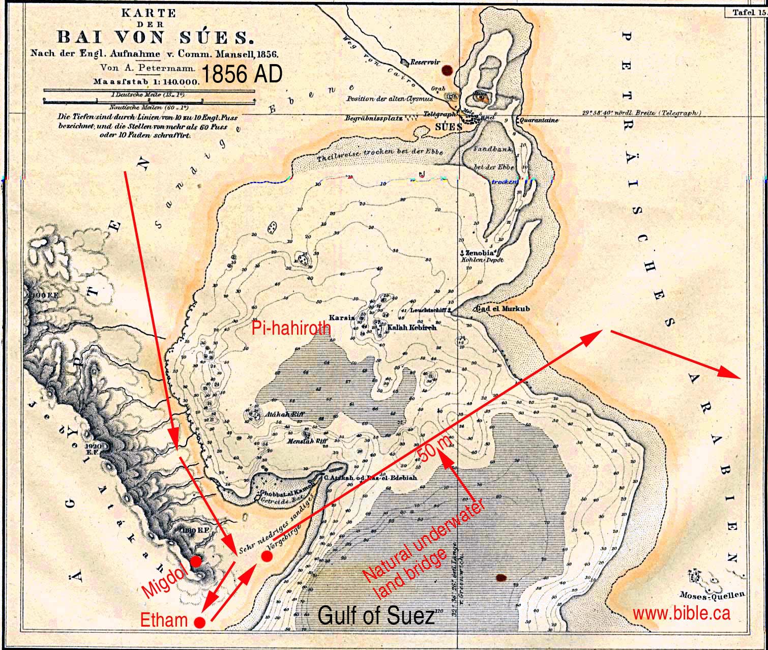
The land bridge is seen on this 1856 AD relief map:
 | |
Contradicts the Bible
|
No wilderness before the crossing: Ex 13:18; Judg 11:16.
|
Etham doesn't fit
|
There are mountains on the west side of the proposed crossing point but they never get any narrower than 800 meters which provides a huge escape path. After crossing past this 800 meter bottleneck, the terrain opens up to a huge flat plain. The Bible says they went past the crossing point, got "Shut in by the wilderness" then God told them to retrace their path back to the previous crossing point. It doesn't fit Etham at all since there is no place for wilderness to "shut them in", forcing them to return again to the actual crossing point they passed the day before.
(Click on photos for high resolution)
|
Assaults common sense
We propose the Red Sea crossing at the Straits of Tiran.
|
Too close to Goshen: 100 km.
Too close to a major Egyptian sea port. The exit point is only 4 km from the sea port of Suez. No security from Egypt on other side. Israel would not rejoice, they would keep running!
Army would never pass through the sea, but move to the "other side of the sea" as Hebrews exit the Sea. Better still, they may have watched from their beech chairs at the port of Suez and waited for Israel to move closer to them.
Illogical route: Hebrews would never take this route, but take east side of the Gulf of Suez, then go south.
No reason to pass the crossing point, get boxed in then return again. It is illogical to not just keep running down the huge open plain, then return and pass through the narrow 800 meter bottleneck.
Also remember that the locust were blown into the Red Sea (Suez) and if this is the crossing point, then the locust would have been there only about 6-10 days. They would still be littered on the shoreline and floating on the water. (Ex 10:19)
Not far enough away to justify their bitter complaints about being in the wilderness: Exodus 14:11-12
|
Timing problems
|
For those who suggest the traditional route of a Suez crossing to Mt. Musa in 44 days there are grave problems. First they say it took 7 days to travel 100 km to the crossing point plus two days waiting for Pharaoh to arrive for a daily rate of travel of 14 km for 7 days. Then they traveled 250 km to Mt. Musa from the Suez in 27 days for an average daily rate of travel of 9 km per day. Although we do not know the days of travel from Goshen to the Red Sea, we do know they took 20 days from the Red Sea to Sinai. We can therefore compute the trip from Goshen to the Red Sea as being 25 days. Ignorance is bliss for those who espouse the traditional exodus route and they have their times all wrong. The actual times are as follows: Total trip: 44 days. Red Sea to Sinai: 20 days. Goshen to Red Sea: 25 days. So the Hebrews took 25 days to travel 100 km to the Suez in easy flat terrain, then took 20 days to travel 250 km to Mt. Sinai in harsh mountainous terrain. For this reason alone the traditional route must be abandoned.
We propose the Red Sea crossing at the Straits of Tiran.
|
 |
Nuweiba Beach crossing must be Accepted.
Nuweiba Beach crossing has brought much evidence to bear to justify this underwater bridge is wear the Israelites crossed. Evidence of chariot wheels of pharaoh's army at this point fits the Bible descriptions of what happened when Pharaoh's army tried to cross the bottom of the Gulf of Aqaba. (Red Sea).
|
Etham doesn't fit
We propose the Red Sea crossing at the Straits of Tiran.
|
There is a very narrow access valley that is only 130 meters wide winding through high mountains to access this beach. Once at the beach, it is clear that the "wilderness of shut them in", but the narrative says they came to the crossing point, then went past to Etham, then turned back. There is simply no place to locate Etham because the beach is so tiny, (28 sq. km.) that Israel would take up all available space. There is no place on the Nuweiba Beach for God to tell them to retrace their path back to the red sea crossing point, forcing them to return again to the actual crossing point they passed the day before. In other words, the area is so small, that once you squeeze 2-3 million people with flocks and herds on the beach, there certainly is no room for them to go to another location (Etham) then return again.
The straits of Tiran fit perfectly. They pass the crossing point them come to Etham. At that point they are shut in. Then God tells them to backtrack and retrace their steps and camp at the actual crossing point.
This critical detail about Etham simply doesn't work at the Nuweiba Beach. If the Nuweiba Beach is where they were shut in by the wilderness, then they had to retrace their steps inland towards the north. Therefore the Nuweiba Beach simply cannot be the crossing point. Being trapped at the Nuweiba Beach with no where to go but inland is exactly what disqualifies this as the crossing point. The straits of Tiran fit perfectly because they came to a dead end, turned back and parked beside the Red Sea. This is impossible at the Nuweiba Beach!
(Click on photos for high resolution)
|
Natural underwater land bridge
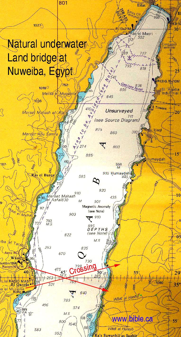
British admiralty nautical depth chart 12
|
We recognize that there are reports of a natural underwater land bridge at Nuweiba Beach. But there are some major problems. The crossing is 15 km wide.
These two graphics below do not represent the actual shape of the land bridge. They are not to scale and are deceptively misleading to the average reader.
The two graphics above are used by those who favor a Red Sea crossing at Nuweiba, but they misrepresent the actual contour of the land bridge. They claim: "Only here, on the shores of Nuweiba, does the 'pathway' drop off at a gradual slope of one in fourteen, to a depth of just over 850 meters. On the Saudi side the slope climbs again at a slope of one in ten." Of course the suggested slop is ridiculous since 1/12 is the building code for wheel chair ramps. To descend to the 765m level at 1/12 slope would take 9 km (765m x 12). But that only takes you to the bottom and the actual deep trough is only 5 km wide. The data to produce the above contour maps were obtained by using a small portable fish finder "Simrad CE32" that has a max depth of 800m according to the owners manual. The actual depth that can be relied upon is much less, given the downward beam is 45 degree angle wide. The manual says that to reach 800 m: "use the 50 kHz for searching in a wider area, determining bottom conditions and going the deepest. The transmitter has a wide transmitter beam with a 45° opening." So they plot 850 meters which is 50m past what the equipment is rated for and the beam is far too wide to gain any valuable slope data. What do you expect from a home fish finder?
According to the British admiralty nautical depth chart 12, the land bridge is not flat as misrepresented above. In fact the depths, starting with the Egypt side, are 0m, 263m, 765m, 285m, 0m. This means that as they started crossing, they were at sea level (0m) then had to drop down immediately to 263 m, then continue for 5 km. Next, as they pass the 5 km mark, they drop down to a valley that is 765 m deep. This valley is 2.5 km down and 2.5 km back up again. and back up again. Next it rises again to the 285 meter level for 5 more km until you rise to sea level on the opposite shore in modern Saudi Arabia. The valley is 1500 feet deep. The CN tower is the tallest building in the world and is only 553m tall. This means that if we placed the CN tower at the deepest spot of 765m, the top of the CN tower would about even with the first 263 m shelf. So they would have to climb down the height of the CN tower in 2.5km to the bottom, then back up the height of the tower again in 2.5 km. That is quite an steep angle to walk down then back up again. The actual slope is 2.5 km to reach a depth of 765m according to British admiralty nautical depth chart 12. 2500m/765 = 1/3.3 slope, which is a 17 degree incline. This assumes a perfect condition slope, when in fact there are likely huge drop off points.
The Straits of Tiran provide a max depth of 205 meters and are clearly a far superior choice for where Israel crossed the Red Sea.
We propose the Red Sea crossing at the Straits of Tiran.
|
Modified depth chart from "The Exodus Case" (page 190), "The exodus Conspiracy" movie. by Lennart Moller.
We propose the Red Sea crossing at the Straits of Tiran.
|
The big problem with this depth chart is that is fails to supply any data at the critical needed point: the bottom of the middle! They took physical soundings with a video camera wire to about the 100 m depth from each shore, then extrapolated the bottle with the little black dotted line. This extrapolation produced a max depth of 240 meters in the middle. Now strangely you can go to home depot and buy a box of 300 meters of video cable for about $200. Why they stopped at only 100 meters is puzzling. Perhaps the only conspiracy here, is that they did not tell you that the ocean floor drops off rapidly at the 100 m depth. Having gone scuba diving twice in the gulf of Aqaba myself, I can tell you that the drop off is abrupt and dramatic and dangerous!
The British naval chart says the depth is 765 meters. The Israeli geological survey map by J.K. Hall and Z. Ben-Abraham says the depth is 800 meters.
We find the use of sport fishing depth finders and home made video camera cables of 100 meters to be unconvincing against the British and Israeli government conclusions.
|
We did not rule out the Nuweiba Beach because 765m is too deep for God to part the sea!
|
We chose the straits of Tiran over the Nuweiba Beach because it fits all the data perfectly not because God could not part 765 m of water. We accept the word of God as inspired. In fact we teach that when God created the heavens and the earth is six literal 24 hour days... He was taking his time! We oppose the theories of skeptics who only postulate naturalistic explanations for miracles and conclude they crossed the Red Sea at the freshwater Bitter lakes. Our God is all powerful and could part the Atlantic.
The grade is part of the issue at the Nuweiba Beach. Since the depth is 800 meters, not 240 m, this makes a huge difference! But God used miracles to assist the Israelites across the Red Sea. So our complaint with grades at the Neweiba Beech crossing that are "consistent with the American Disability Act" is that these gentle slops do not exist at Neweiba! The grades are much steeper! Having said this, God could have performed the crossing at Neweiba as well! He gave them supernatural help! See this link: supernatural help.
The depth at the straits of Tiran is only 205 meters. But the distance for this drop is shorter, creating a steeper grade. We fully discuss this in detail at: Straits of Tiran. First, the Bible says God gave Israel supernatural help so that they would not stumble while crossing the Red Sea at the Straits of Tiran. Second, is it likely that in the past, the depth was less than what we see today and that the tides and currents have actually dug the depth deeper over time than it was 3500 years ago. Of course God could have performed a miracle and silted in the depth at both Tiran and Neweiba somewhat to make the bottom higher.
We propose the Red Sea crossing at the Straits of Tiran.
|
(Click on photo for high resolution)
- Green Light: The Petra area is where Kadesh Barnea is located: Using scripture, everyone before 1881 AD located Kadesh Barnea in the Arabah Valley, or near Petra. Eusebius stated that Kadesh and Mt. Hor were at Petra.
- All candidates for or Kadesh Barnea that are within the promised land should be immediately rejected. Gen 15:18 sets the boundaries for the promised land between Egypt and Israel at the wadi El-Arish, known also as the "River of Egypt" in scripture. Judah's southern boundary was at the wadi el-Arish: Numbers 34:5; Joshua 15:1,4,47
- Red light: Ein el-Qudeirat has been the almost universal choice for Kadesh Barnea since 1916 AD. While Ein el-Qudeirat is outside the modern border of Israel, it is a full 18 km east of wadi el-Arish, the biblical border between Israel and Egypt. It therefore cannot be where Kadesh Barnea is located since this would mean Israel spent 38 years already in the promised land at Kadesh.
- Red light: Ein Qedeis was the choice for Kadesh Barnea from 1881 AD to 1916 AD. It is located only 10 miles south of Ein el-Qudeirat. Both should be reject out of hand on the simple basis that both are with the formal boundaries of the promised land.
No comments:
Post a Comment